The smell hits you before the heat does. Somewhere between the tarmac and the taxi rank, Sumatra announces itself — wet earth, woodsmoke, the faint sweetness of something flowering you cannot name. Indonesia's second-largest island is not a destination that eases you in. It pulls you under immediately, completely, the way equatorial places do when they have been left mostly to themselves.
Most athletes who come here arrive through Medan, blinking in the lowland humidity, already recalibrating. The island stretches nearly 1,800 kilometers from northwest to southeast, split down its spine by the Barisan mountain range, flanked on one coast by the Indian Ocean and on the other by the calmer Strait of Malacca. The dry season — May through September — pulls the clouds back just enough. Not to reveal something tame. To reveal something possible.
What Sumatra offers athletes is not convenience. There are no tidy race courses, no manicured trails marked with distance signs. What it offers instead is scale, and the particular sharpness that comes from moving through a landscape that predates every human ambition laid over it.
Lake Toba: Altitude, Silence, and Open Water
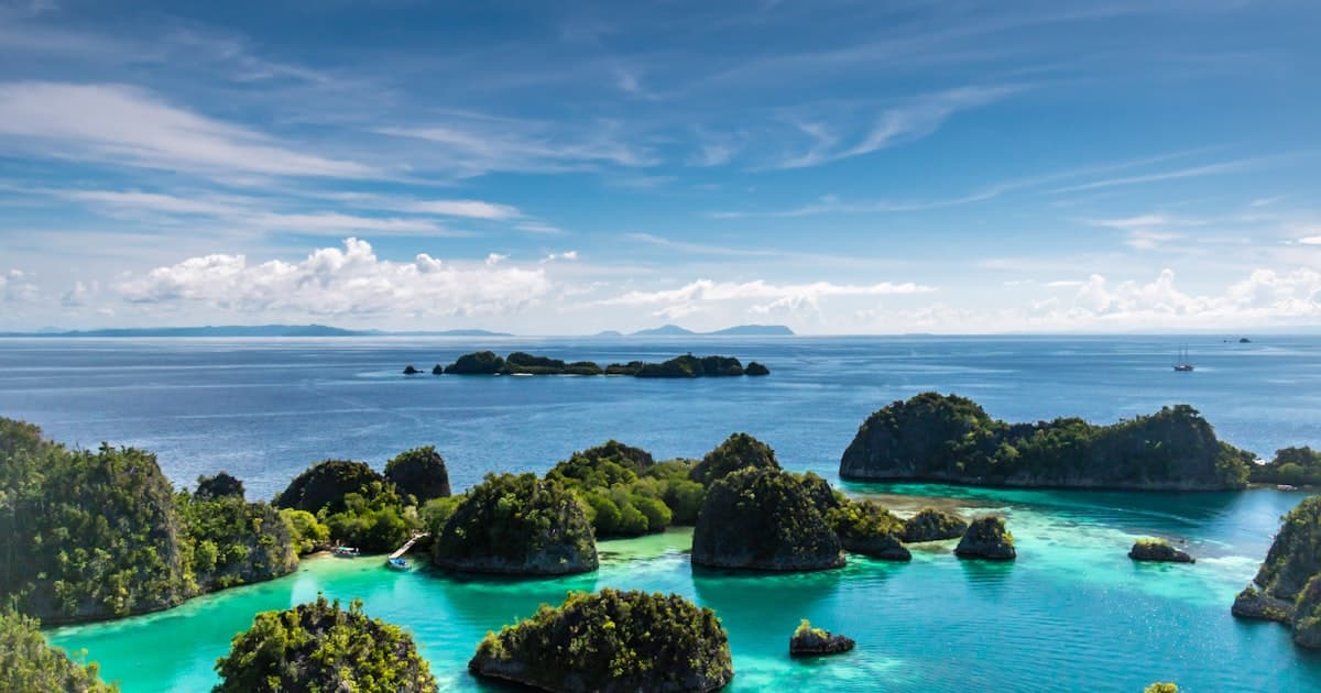
Four hours south of Medan by road, Lake Toba sits inside the caldera of a supervolcano — the largest volcanic lake on earth, 900 meters above sea level, 100 kilometers long. The water is cold by Sumatran standards, blue-black in the early morning, turning silver by midday. Open-water swimmers find something here they rarely find elsewhere: a body of water vast enough to feel oceanic, calm enough to read every stroke.
The island of Samosir sits in the center of the lake. Runners who base themselves here discover a loop of approximately 35 kilometers around the island's perimeter — unpaved in stretches, climbing through traditional Batak villages, dropping back to the shoreline where fishing boats rest at odd angles. The altitude is not punishing, but it is felt. Legs go heavier earlier than expected. The air is cleaner than it has any right to be.
“The lake does not care what time you finish. It only asks that you finish.”
Toba rewards the early riser. By 5:30 AM the mist is still sitting in the middle distance, and the volcanic ridgeline to the south catches the first light before everything else. If you are going to swim, swim then. If you are going to run, run then. The heat that builds by 10 AM is a different creature entirely.
Bukit Lawang: Into the Canopy
Northwest of Medan, following the Bahorok River into the foothills of the Leuser Ecosystem, Bukit Lawang is the entry point to one of the last intact lowland rainforests on earth. It is also, quietly, one of the most demanding trekking environments in Southeast Asia.
The trails here are not trails in any conventional sense. They are lines through undergrowth maintained by guides who have been walking them since childhood. They cross the river on rope bridges and improvised logs. They climb sharply through fig forest and secondary growth, then level out into something older and darker where the light arrives broken. Orangutans move through the upper canopy — you hear them before you see them, if you see them at all.
Jungle trekking in Bukit Lawang is measured not in kilometers but in hours. A two-day route into the interior with a hammock camp overnight will push most athletes harder than they expect. The terrain is relentless on ankles and knees. The humidity turns every incline into a conversation with your own capacity. Guides here — local men who grew up at the forest edge — move at a pace that is humbling to watch.
Connect with training partners, earn travel miles, and discover terrain worth crossing borders for.
Join ZealZagFollow us on InstagramKerinci Seblat: The High Country
Kerinci Seblat National Park covers 1.3 million hectares across four provinces. Inside it sits Mount Kerinci, at 3,805 meters the highest volcano in Indonesia and the highest peak in the country outside of Papua. The trail to the summit begins at around 1,900 meters and gains nearly 2,000 meters over roughly 13 kilometers — a route that experienced mountain runners have covered in under six hours, though the standard ascent takes two days.
The dry season makes Kerinci possible. The wet season makes it inadvisable. In May and June the summit is often clear by mid-morning before cloud builds again in the afternoon. The crater rim offers a full panoramic view of the Barisan range falling away in every direction, the lowland forests visible far below as an unbroken green.
Below the summit zone, the national park holds trail networks through cloud forest — mossy, root-tangled, occasionally steep — that reward hikers willing to move at the pace the terrain demands.
“Kerinci asks for patience before it asks for fitness. Most people get that order wrong.”
Mentawai Islands and Bukittinggi: Two Kinds of Edge
Off the west coast of Sumatra, reached by ferry from Padang, the Mentawai Islands have been known to surfers for decades. The reef breaks here — Macaronis, Lance's Right, Telescopes — are among the most consistent in the world. The dry season aligns with the best swell, and the water temperature hovers around 28 degrees Celsius year-round. For athletes who surf, the Mentawais represent a kind of benchmark: technical, powerful, punishing to the unprepared, transcendent when you are ready.
Inland, two hours north of Padang in the Minangkabau highlands, Bukittinggi sits at 930 meters surrounded by volcanic peaks and canyon landscapes. The Sianok Canyon — a 15-kilometer ravine cut by the Batang Sianok river — has become a destination for trail runners looking for something off the established circuit. The canyon floor trail is doable in an easy half-day. The rim loop, combining jeep tracks and single-track through village gardens, is a different proposition entirely.
What Sumatra Does to Athletes
There is a specific kind of clarity that comes from moving through environments that do not accommodate human discomfort. Sumatra is full of these environments. The heat, the terrain, the scale of the forest — none of it adjusts to what you brought. You adjust to it.
Athletes who spend time here consistently describe a recalibration — not of fitness, but of what fitness is for. A trail runner from Stockholm who spent three weeks moving between Bukit Lawang and Kerinci described it plainly: she had stopped thinking about pace and started thinking about duration, about completing something, about the quality of attention required to not misjudge a root on a descent in dim forest light.
“The island takes the number off your chest and gives you something harder to measure in its place.”
This is not mysticism. It is what happens when athletic practice encounters genuine wilderness — when the external feedback you usually rely on disappears, and you are left with your own unmediated assessment of how you are doing and why it matters. Sumatra provides that at scale.
Local Athletes and the ZealZag Connection
There is an athletic culture here that most visitors never encounter. In Medan, trail running communities have been organizing since the mid-2010s, using the foothills of the Bukit Barisan as a training ground. In Padang, open-water swimmers train in the bay before dawn. In the villages surrounding Kerinci, young climbers know the mountain's routes better than any guidebook has recorded.
ZealZag was built for exactly this kind of exchange. Local athletes on the platform list the routes they run, the conditions they train in, the times of year when a particular climb or swim is at its best. Visitors who arrive with a training block in mind can connect with someone who trains here every week — not for a guided tour, but for a shared session. That distinction matters. A guide shows you a place. A training partner shows you how they live inside one.
Sumatra's local athletic community is not trying to replicate what exists in European trail running or Australian ocean swimming. They are doing something contextually different — shaped by the terrain, the climate, the culture of the island itself. ZealZag makes those connections possible before you arrive, so that by the time you are standing in Medan with your gear bag and your jet lag, you already know who you are running with on day two.
Getting to Sumatra
The main entry points are Kualanamu International Airport outside Medan in the north, and Minangkabau International Airport outside Padang in the west. Both receive connecting flights via Singapore Changi, Kuala Lumpur, and Jakarta. From Europe or the Americas, a two-connection routing is standard; journey time from London runs around 18 hours, from Los Angeles closer to 24.
Within the island, distances are long and roads are variable. The Trans-Sumatra Highway connects the major cities but does not hurry. A private driver hired for the week is the most practical solution for athletes covering multiple regions. For Mentawai, the public ferry from Padang takes six to ten hours depending on destination; chartered speedboats are faster and available through accommodation operators on the islands.
Accommodation options cover a wide range — from basic guesthouses in Bukit Lawang that open directly onto the forest, to modest hotels in Bukittinggi and Medan. The Mentawai surf camps are the most developed infrastructure on the island for visiting athletes, with packages that include meals, boats, and board transport built into the rate.
The dry season is the window. May through September. After that, the rains come back, the trails become rivers, the swell becomes unpredictable. You have four months. That is enough, if you use them right.