The redwoods do not care that you are fit. They were here two thousand years before you started training, and they will be here long after your GPS watch corrodes into the soil. Walking beneath coast redwoods for the first time — real redwoods, the coastal giants of Humboldt and Del Norte counties — produces a specific kind of humility that no mountain range can quite replicate. It is not the altitude that gets you. It is the scale. The canopy closes two hundred feet overhead and the light becomes something filtered and ancient, and you feel, briefly and usefully, small.
Northern California is not a single landscape. It is five or six distinct wildernesses pressed together without apology. In the space of a long weekend you can move from fog-soaked old-growth forest to volcanic alpine terrain to surf-battered headland cliffs. Athletes who come here expecting scenery get something harder to metabolize: they get a confrontation with the size of the natural world, and with their own relative insignificance inside it. That confrontation tends to stick.
May through September opens this landscape almost entirely. The snowpack on Mount Shasta consolidates into climbable couloirs. The Lost Coast Trail dries enough to move fast. The Mendocino headlands turn green and then gold. The rivers running out of the Trinity Alps clear from snowmelt-gray to a cold, impossible blue. If you have been stacking training blocks in a city, this is what you come here to remember.
The Lost Coast: Running the Edge of the Map
The King Range drops into the Pacific without warning. There are no roads along this stretch of coastline — the terrain defeated the highway engineers and they simply gave up — which means the only way to travel the Lost Coast is on foot, on the beach, at the mercy of tide tables. The Lost Coast Trail runs roughly twenty-five miles from Mattole Beach south to Shelter Cove, and the serious version of doing it means moving fast and carrying only what you need.
Trail runners have been creeping into this corridor for years, drawn by the combination of technical beach running, black sand that swallows your ankles, and mandatory creek crossings that require you to check the tide before committing. The wildlife does not retreat for you here. Black bears work the tideline at dawn. Roosevelt elk move through the King Range as though the landscape belongs to them, which it does. You run through their territory as a guest, which is the correct relationship to the wilderness.
“The Lost Coast does not give you a PR. It gives you something else.”
The fastest runners move from Mattole to Shelter Cove in a single long day. Most people take three. Both approaches are legitimate. What matters is that the trail stays in your legs — the sand, the headland scrambles, the creek fords — as a kind of specific fatigue you will spend weeks interpreting.
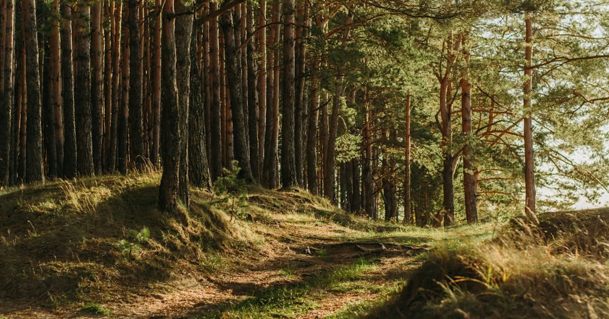
Redwood National and State Parks: Moving Through Deep Time
Avenue of the Giants is a thirty-two mile stretch of old highway running through Humboldt Redwoods State Park, and cyclists treat it the way climbers treat moderate ridgelines: a line you do for the experience of being inside it, not for the numbers it produces. The road rolls gently, the canopy complete overhead, the shoulder soft with fallen needles. Road cyclists and gravel riders both find their way here.
For runners, the trails threading off the Avenue into the old-growth groves are something else entirely. Flat, rooted, with light that moves through the canopy in slow shafts — the pace you find here is almost involuntary. You slow down. The forest seems to demand it. The Prairie Creek Redwoods section of the park adds coastal bluff running and beach access, and in early summer the Roosevelt elk herds gather in the meadows at Gold Bluffs Beach in numbers that make you stop and simply watch.
Redwood National Park proper, further north near Crescent City, holds the Tall Trees Grove — access limited, permit required, the correct way to do it. The trees there are taller than the ones people photograph. The experience of running the access trail down to the grove and back before the crowds arrive is close to private. You earn the solitude with an early start.
Connect with training partners, earn travel miles, and discover terrain worth crossing borders for.
Join ZealZagFollow us on InstagramMount Shasta: The Volcano That Filters Intentions
Mount Shasta rises 14,179 feet from a landscape that is otherwise valley-flat, which means you see it from eighty miles away and spend the whole drive watching it grow. That visibility is the first thing it does to you. By the time you reach the mountain, you have already been in relationship with it for hours.
The standard Avalanche Gulch route is a mountaineering objective, not a hike. Even in June, when the snow consolidates and the window opens, the climb demands crampons, ice axe, the ability to self-arrest on forty-degree neve, and the judgment to turn around when the mountain asks it of you. The summit attempts that fail are not failures — they are the mountain teaching patience. Summit success rates are well below fifty percent on any given attempt, and the athletes who understand that number before they start tend to perform better on the mountain.
“Shasta is a serious glacier climb wearing the costume of a manageable day out. The costume fools a lot of people.”
Ski mountaineers use the Avalanche Gulch line into June, earning vertical on foot and descending on splitboards and randonée skis. Trail runners with mountaineering experience push to the crater rim and back as a long training effort. The Whitney Glacier and Hotlum routes are technical enough to demand rope teams. The mountain has room for all of these approaches and does not organize itself around any of them.
Mendocino and the Pacific Coast: Surfing the Edge Season
The Mendocino Coast in May and June sits in a transitional weather window that produces waves and mild air in combination that the midwinter Pacific does not reliably offer. Point Arena and Fort Bragg draw surfers looking for less-crowded alternatives to the Bay Area's established breaks. The swells from late spring storms are cleaner and more organized than the grinding winter surf, and the water temperature, while cold — low fifties Fahrenheit — is manageable in a five-four wetsuit.
Cyclists building volume treat Highway 1 between Bodega Bay and Mendocino as a classic training corridor. The road rises and falls along the bluffs, exposed to headwinds that punish you going north and reward you on the return. The grades are never extreme, but the wind turns a century into a real day's work. Local gravel roads thread inland through redwood second-growth and sheep pasture, and the detail-oriented rider can string together loops that keep them off the highway entirely.
The Trinity Alps: A Wilderness With Almost No One In It
The Trinity Alps Wilderness sits in the interior of the state, north and east of the Mendocino coast, and it remains among the least-visited wilderness areas in California despite holding more than five hundred thousand acres of granite peaks, clear lakes, and river corridors that rival anything in the Sierra. The trails are maintained but uncrowded. The fishing is serious. The high route options are demanding enough to reward technical hikers and trail runners who want long days in the mountains without the permit lotteries that govern the Sierra Nevada.
The Swift Creek and Canyon Creek drainages offer multi-day itineraries with significant elevation gain and the kind of solitude that has become genuinely rare in the American West. In July, when the Sierra meadows are still patchy with snow, the Trinity Alps lower elevations are dry and fast.
What Northern California Does to Athletes
There is a version of training that is about control — pace targets, wattage outputs, threshold sessions that confirm the data. Northern California is not interested in that version of you. The terrain is too variable, the weather too indifferent, the scale too large for the training plan to survive contact with it.
What the region offers instead is recalibration. Athletes who spend time on the Lost Coast, or a week moving through the Trinity Alps, or a summit attempt on Shasta that turns around at thirteen thousand feet, come away with a different relationship to effort and outcome. They have been in landscapes that don't respond to their performance — that exist completely outside the framework of their sport — and that indifference is clarifying. You stop performing and start moving. There is a difference.
“The wilderness does not grade on a curve. It simply continues.”
Finding Local Athletes Through ZealZag
The athletes who live and train in Northern California are not difficult to find if you know where to look, but they are specific people with specific knowledge — the runner who knows the tide windows on the Lost Coast, the climber who has done Shasta's Hotlum-Bolam route four times and can read the snowpack. ZealZag connects visiting athletes to these locals directly, through profiles that surface by sport, region, and season.
A cyclist planning a week on the Mendocino coast can connect with local riders who know which gravel roads open in May and which ones stay muddy until July. A mountaineer targeting Shasta in June can find a partner with glacier travel experience and familiarity with the current conditions on Avalanche Gulch. The platform exists to make that connection simple — not to replace the wilderness with information, but to make sure you arrive prepared to move through it honestly.
Getting to Northern California
San Francisco International handles the most traffic, and the rental car infrastructure there is deep. Sacramento is closer to Mount Shasta and the northern interior. For the Lost Coast specifically, the closest functional airport is Arcata/Eureka (ACV), a small regional hub with connecting service from San Francisco and Los Angeles — it adds a leg to the itinerary but saves four hours of driving.
The drive north on US-101 from San Francisco to the redwood country takes five hours without stops, more with them. The drive east from the coast to Shasta City from Redding is an hour. Cell service disappears in the Trinity Alps and along much of the Lost Coast, which means paper maps and downloaded offline data before you leave the last town. The Lost Coast requires tide chart planning — the NOAA Humboldt Bay tide predictions apply to Mattole Beach, roughly adjusted — and this is not optional. The impassable rocky points between Punta Gorda and Sea Lion Gulch will strand you if you do not account for the water.
Come with margin. Come with more days than you think you need. Northern California tends to reorganize itineraries.