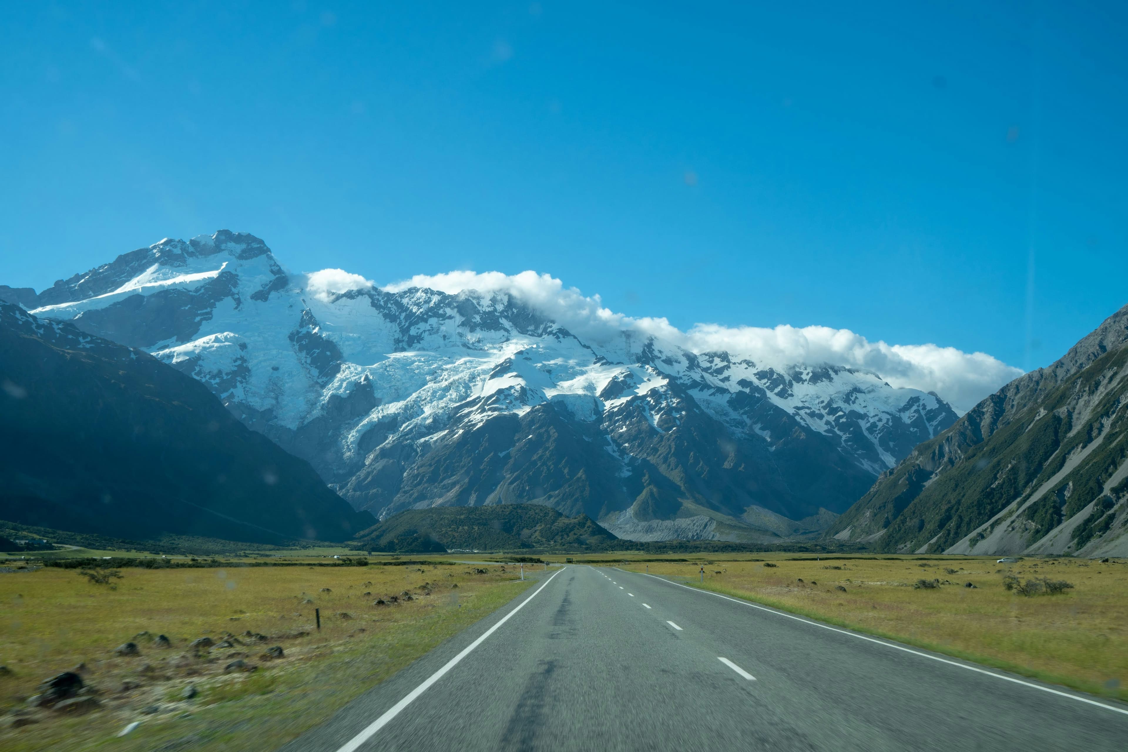
The mountain does not care how fit you are. Aoraki — which the Māori called the Cloud Piercer, and which the rest of the world knows as Mount Cook — rises 3,724 metres above the Canterbury Plains of New Zealand’s South Island and has stood there, indifferent, since long before anyone thought to measure it. It is the highest peak in the Southern Alps, and in the whole of New Zealand. On a clear day, which is not guaranteed and never promised in this part of the world, it dominates every line of sight for twenty kilometres in every direction.
The Hooker Valley Track runs directly toward it. Ten kilometres return. 120 metres of elevation change. Three swing bridges over a river the colour of old pewter. By the standards of serious alpine hiking, it is almost laughably accessible. And yet athletes who have completed the hardest routes on earth come to the Hooker Valley and find themselves standing at the end of it — at the edge of a lake where icebergs drift in the July cold — reaching for words that don’t arrive. The mountain does not reward effort. It rewards presence.
Aoraki does not ask for your credentials. It simply asks whether you came.
The Cloud Piercer and the People Who Named Him
Aoraki / Mount Cook National Park covers 707 square kilometres of the central Southern Alps, a landscape shaped over millions of years by the collision of the Pacific and Australian tectonic plates. The mountains here are still rising — the Southern Alps gain height faster than erosion can remove it — and the glaciers that carved the valleys are retreating, leaving behind lakes of extraordinary colour and moraine walls that dwarf the trees growing on their flanks.
For Ngāi Tahu, the indigenous Māori of the South Island, Aoraki is not merely a mountain. He is an ancestor — the eldest son of the sky father Rakinui — whose canoe was stranded on a reef and turned to stone, lifting into the sky to become the peaks of the Southern Alps. The summit of Aoraki is the most sacred point in the South Island, and the Hooker Valley Track passes through the Tōpuni area, a region of special cultural and spiritual significance to Ngāi Tahu. The mountain has two names because it has two histories, and both are true.
The European mountaineering story begins in 1882, when the Irish explorer William Spotswood Green made the first serious attempt on the summit. He didn’t reach it. The first successful ascent came in 1894, by a New Zealand-led party that took a route from the east face. The Alpine Memorial near the start of the Hooker Valley Track stands for all the climbers who came after them and did not return — a quiet, weathered monument at the edge of the grassland that marks the beginning of the walk.
Three Bridges and a River That Carries the Mountain
The track begins at White Horse Hill Campground, two kilometres from Mount Cook Village at the end of Hooker Valley Road. The car park is large and well-signed. The shelter at the trailhead has information panels. None of this prepares you for what happens when you walk the first hundred metres and the valley opens up.
The Hooker River runs alongside the track for most of its length. Its water is not blue or clear or the green of normal rivers. It is the colour of pale slate — a milky grey-blue that comes from the glacial rock flour suspended in the meltwater, the fine powder that results from the glacier grinding the schist and greywacke beneath it over thousands of years. This river is carrying the mountain downstream. Every cubic metre of that pewter water contains the remnants of something ancient being slowly dismantled.
“The river is the colour of pale slate. It is carrying the mountain downstream, one particle at a time.”
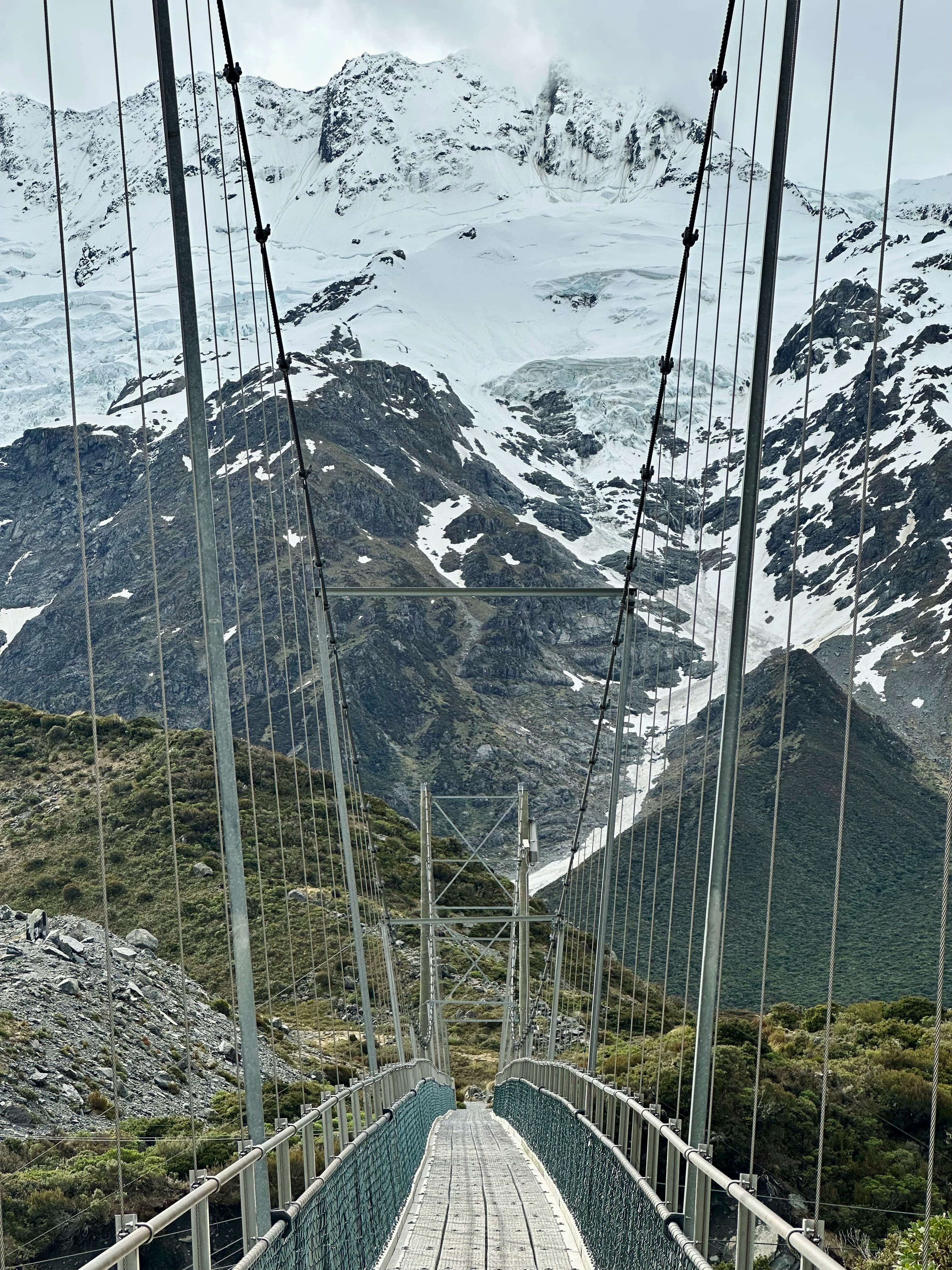
The first suspension bridge — Lower Hooker Suspension Bridge — crosses the river downstream of Mueller Glacier lake. The bridges here were rebuilt in 2015 and are wide, solid, and well-maintained. They still move underfoot in a way that reminds the walker that the river below is not decorative. The second bridge, Hooker Bluff Bridge, crosses the river again upstream of Mueller Glacier lake, and from this point the track turns north into the deeper valley and Aoraki begins to assert itself on the horizon.
This is where most visitors stop talking. The mountain fills the head of the valley in a way that makes conversation feel beside the point. Its summit pyramid, usually wrapped in some degree of cloud or lenticular cap, rises above the surrounding peaks with the kind of authority that does not need announcement. Below it, the Hooker Glacier descends in a long tongue of broken ice toward the terminal lake. The whole system — summit, glacier, river, valley — is visible from the track in a single unobstructed sweep.
The vegetation changes as the track climbs gently north. Near the trailhead, the grassland is open and low. Further in, snow tussock takes over — the long, amber-gold native grass that moves in the wind in a way that gives the valley floor the appearance of something alive and breathing. Among the tussock, in summer, Mount Cook Lily blooms: the world’s largest buttercup, its white flowers appearing incongruously delicate against the scale of the mountains behind them. The kēa — the alpine parrot, the only mountain parrot in the world, a bird of alarming intelligence and irreverent personality — can often be heard somewhere nearby, its call carrying across the valley like a question.
Connect with training partners, earn travel miles, and discover terrain worth crossing borders for.
Join ZealZagFollow us on InstagramHooker Lake: The Place Where the Glacier Lets Go
North of Stocking Stream, the valley floor becomes marshy and the track continues on a wooden boardwalk. The third and final bridge — Upper Hooker Bridge — crosses the river just below the moraine walls of Hooker Lake, and from there the track climbs gently to the lookout point at the height of the moraine wall.
Hooker Lake did not exist a century ago. It formed as the Hooker Glacier retreated through the twentieth century, uncovering the depression behind the terminal moraine and filling it with meltwater. It is what glaciologists call a proglacial lake — a lake that forms at the snout of a retreating glacier — and it is still growing as the glacier continues to pull back. The lake is roughly 3 degrees Celsius. In summer, icebergs calved from the glacier’s terminus drift across its surface — blocks of ancient compressed ice the colour of deep water, some the size of a small car, others the size of a building, all of them moving with the slow indifference of things that have existed far longer than the people watching them.
“The icebergs are pieces of the glacier that have let go. They drift across the lake in the summer light, indifferent and ancient, until they melt.”
Above the lake, Aoraki fills the sky. From the lookout at the end of the Hooker Valley Track, the view is unobstructed in a way that is rare for a mountain of this magnitude — no ridge in the way, no intervening peak, nothing between the walker and the summit except 3,700 vertical metres of air and ice and rock. It is the closest any walking track in New Zealand comes to the highest point in the country. You do not need crampons, or rope, or an ice axe, or mountaineering experience to stand here. You need only to have walked ten kilometres on a well-maintained track.
That fact is either the most democratic thing about this place or the most humbling, depending on the day and the weather and the particular quality of light on the glacier. Both are correct.
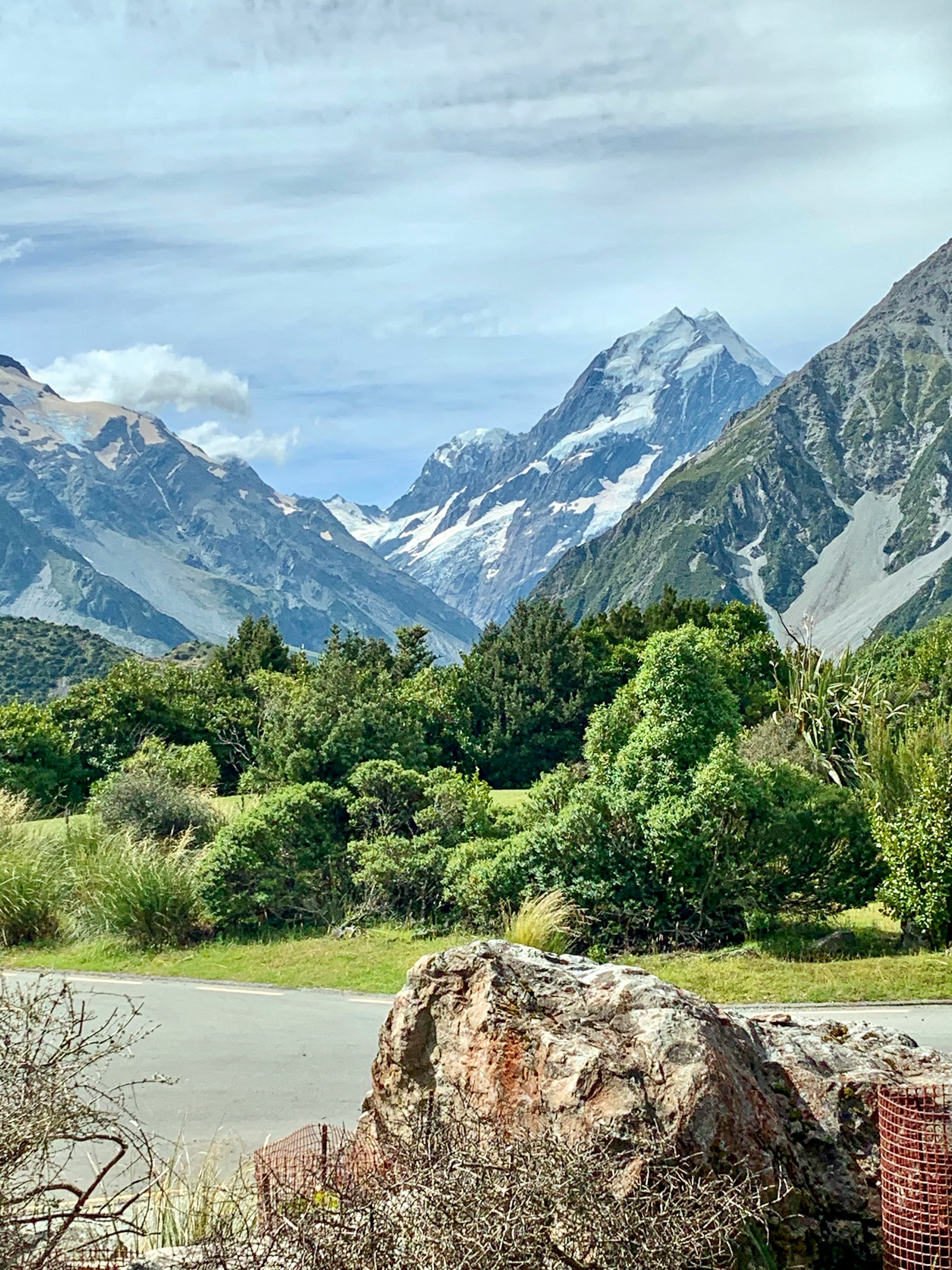
Photo: Chris Lean
What the Mountain Does to Athletes
Athletes who come to the Hooker Valley Track often describe something that training logs cannot capture. The runner who covers fifty kilometres a week finds that the mountains make the distance irrelevant. The cyclist who climbs mountain passes finds that the glacier makes personal records feel temporary. This is not failure. It is recalibration — the specific kind that only scale can produce, and that effort alone cannot buy at any price.
There are harder walks in Aoraki / Mount Cook National Park. The Mueller Hut Route climbs 1,000 metres on a full day of serious effort. The Ball Pass Crossing is a multi-day technical route that demands genuine alpine skills. The Hooker Valley Track demands none of this. But experienced athletes report that it stays with them longer than routes that took three times the effort on mountains a third the size.
That is the specific thing Aoraki does. It reorders priorities without asking permission. The FTP numbers, the pace targets, the summit counts — none of it disappears, but all of it shifts slightly in the hierarchy of things that matter. Most athletes don’t expect that from a ten-kilometre walk on flat ground. That is exactly why it works.
“The FTP numbers, the pace targets, the summit counts — none of it disappears. But all of it shifts slightly in the hierarchy of things that matter.”
The local athlete who knows this valley in every season — in the amber light of autumn when the tussock turns gold, in the blue cold of winter when the track ices and the icebergs are larger and the lake is partly frozen, in the white afternoons of summer when the Mount Cook Lily is in flower and the kēa circles overhead — carries knowledge that no trail guide can convey. They know when the weather turns without checking a forecast. They know which hour makes the glacier look impossible. They know the valley the way people know things they have returned to dozens of times, across many years, in all conditions.
That athlete is invisible to most visitors. They are not in the guidebooks. They are not on the trail apps. They are somewhere in the valley, in weather that most people drove away from, doing what they have always done.
ZealZag puts them on the map. That is the only thing we do. But it turns out to be everything.
How to get to the Hooker Valley Track
Aoraki / Mount Cook National Park is located in the Mackenzie Basin of New Zealand’s South Island, approximately 330 kilometres southwest of Christchurch and 260 kilometres northeast of Queenstown. The park is accessible via State Highway 80 from the southern end of Lake Pukaki. No permit is required and there is no entry fee. The trailhead is at White Horse Hill Campground at the end of Hooker Valley Road, 2.5 kilometres from Mount Cook Village.
- Distance: 10 kilometres return
- Elevation change: 120 metres
- Estimated time: 3 to 4 hours return
- Difficulty: Easy to moderate
- Open year-round — microspikes and poles recommended in winter
- Weather changes rapidly; check forecasts before departure